

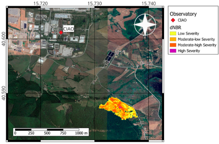
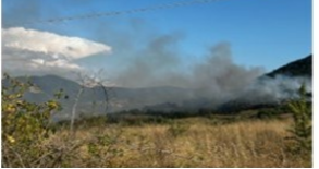
On 16 July 2024, around 15:00 UTC, a fire started in Potenza surrounding on a hill located 2 km from the CIAO (CNR-IMAA Atmospheric observatory) which is part of ACTRIS. The fire was totally under the control of the local fire brigade at about 22:00 UTC. The burned forests belong to the category of mesophilic and meso-thermophilic oak woods, primarily characterized by Turkey oak (Quercus cerris). These forests represent one of the most extensive forest formations in Basilicata, dominating the region’s hilly and mountainous landscape. The extent of the burnt area and the location of CIAO can be seen in Figure 2, the former being estimated based on data from MSI (MultiSpectral Instrument) onboard the Copernicus Sentinel-2. Specifically, we used MSI Level 2 data in the short-wave infrared (SWIR) for a pre-fire and post-fire satellite overpass (i.e., 15 July 2024 at 00:00 UTC and 17 July 2024 at 00:00 UTC).
Publication: https://www.mdpi.com/2072-4292/17/15/2538#
Data availability:
The data used in this study are openly available through the ACTRIS-EARLINET data portal (https://data.earlinet.org, last access: 12 November 2024). They are also part of the ACTRIS-EARLINET 2024 Aerosol Optical Property Profiles over Potenza (Italy) dataset, generated by ACTRIS ARES Data Centre Unit, and accessible via the following DOI: https://doi.org/10.57837/cnr-imaa/ares/actris-earlinet/2024/pot/aerosol_optical_property_profiles accessed on 11 April 2025. For the cloud remote sensing component, the data are available at the Cloudnet data portal (https://cloudnet.fmi.fi, accessed on 11 April 2025) and on the ACTRIS data portal (https://data.actris.eu, accessed on 11 April 2025).